 Catalogo de metadatos del IGME
Natural hazard zones
Type of resources
Available actions
Topics
Provided by
Representation types
Update frequencies
status
Service types
Scale
-
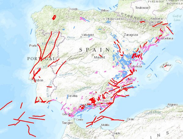
Visualisation service of QAFI, a database of faults with geological evidence of proven activity during the Quaternary period (the last 2.6 million years according to the limit officially established by the SQS in 2009) of the Iberian Peninsula. It is a project in constant revision and updating as a result of the progress of studies and knowledge about the structures capable of generating earthquakes in Iberia, and can never be considered complete or definitive, both because of the scientific nature of the data contained in it, and because of the modus operandi used in its construction: the altruistic collaboration of numerous researchers in Earth Sciences.
-
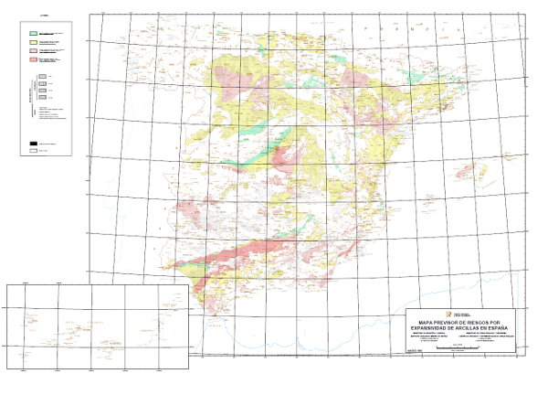
Map with the geographical distribution of the areas where similar expansivity is assumed for the clays, which have been classified into four groups: none to low, low to moderate, moderate to high and high to very high. The different mapped units have been assigned age (4 possible) and lithology (7 different types). The map also shows the surface formations without distinction.
-
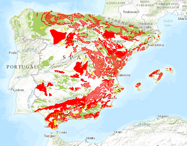
Map delimiting the areas with different types of land movements, representing the most intense and frequent movements. It therefore shows the distribution and extent of the most problematic areas from a practical point of view. Land movements are classified into four main groups: horizontal component movements (landslides and landslides), vertical component movements (subsidence and subsidence, and expansive clays), unstable processes in coastal areas and movements related to mining operations. Areas with significant erosion processes are also included. This map, published in 1987, was drawn up entirely by staff of the Geological Survey of Spain in response to the need for information on geological hazards and risks on a national scale.
-
QAFI is a database of faults with geological evidence of proven activity during the Quaternary period (the last 2.6 million years according to the limit officially established by the SQS in 2009) of the Iberian Peninsula. It is a project in constant revision and updating as a result of the progress of studies and knowledge about the structures capable of generating earthquakes in Iberia, and can never be considered complete or definitive, both because of the scientific nature of the data contained in it, and because of the modus operandi used in its construction: the altruistic collaboration of numerous researchers in Earth Sciences. QAFI, both in Access format and geospatially represented, is hosted and maintained by the Geological Survey of Spain (IGME), and is accessible to the entire scientific and technical community and society in general.
-

The Predictive Map of Expansivity Risks of Spanish Clays at a scale of 1:1,000. 000 delimits the clay formations, classifying them into 4 grades according to their expansivity potential: Non-expansive clays or clays dispersed in a non-clay matrix: No or low risk of expansivity; Subordinate expansive clays or clays located in climatic zones without an annual humidity deficit: Low to moderate expansivity risk; Locally predominant expansive clays located in climatic zones with annual moisture deficit: Moderate to high expansivity risk; Predominant expansive clays in areas where expansivity problems have occurred. High to very high expansivity risk. The term expansivity defines the capacity of the soil to undergo volume changes when its moisture conditions are modified, or to generate pressures if expansion is prevented. This map was made by the Geological Survey of Spain (IGME) with the collaboration of the Centro de Estudios y Experimentación de Obras Públicas (CEDEX) in 1986.
-
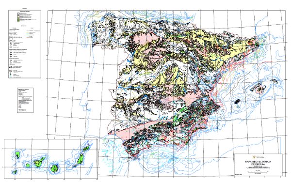
The Neotectonic Map expresses those structural, morphological, stratigraphic and other features that show relatively recent movements (from the period considered neotectonic), as well as the type of stress to which the peninsula is subjected. Its objectives are to identify deformations from the Middle Miocene - Upper Miocene boundary to the present day. The materials have been classified into six categories, two for volcanic materials differentiated by age; and four for the rest of the materials, with four subdivisions according to age. It also includes tectonic structures, stress and deformation directions, diapiric structures and other related phenomena, all with age expression. The map contains information on the Spanish continental shelf. This map, of national scope, has been produced by the Geological Survey of Spain in collaboration with the National Radioactive Waste Company (ENRESA).